- Página de inicio /
- Electrónica /
- GPS, Finders & Accessories /
- Sports & Handheld GPS /
- Handheld GPS Units /
- PPK, NOAA RTK GNSS Survey Equipment GPS Recei...
0 ratings




Nº de artículo:
143127275
PPK, NOAA RTK GNSS Survey Equipment GPS Receiver with IMU Rover & Base Handheld Collector Land Surveying Equipment, Survey Software(Include
91% of respondents would recommend this to a friend
Nº de artículo:
143127275
USD 3099
Price Details
Excluding Shipping & Custom charges ( Shipping and custom charges will be calculated on checkout )
*All items will import from Estados Unidos
1%
0 ratings
Escribe una opinión
En stock
 Importado de la tienda USA
Secured transaction
Ubuy works hard to protect your security and privacy. Our advanced payment security system ensures confidentiality by encrypting your information during transmission using AES (Advanced Encryption Standards) and SSL (Secure Socket Layer) protocols. Your payment details are 100% secure as we do not share your payment details with third party sellers.
Our Top Logistics Partners


Unsurpassed Precision: Our RTK technology ensures centimeter-level accuracy, providing you with reliable measurements for the most demanding surveying tasks.
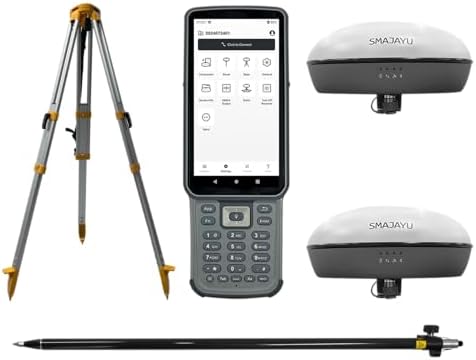
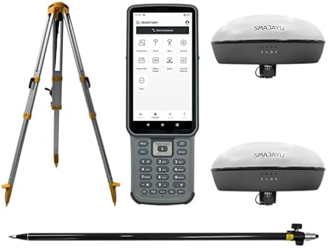
Este paquete contiene 3 elementos


Fast
Shipping

Free
Return*

Secure Packaging

100% Original Products

PCI DSS Compliance

ISO 27001 Certified



What Stands Out
Precision GNSS
Utilizes NOAA RTK technology for high-accuracy land surveying, minimizing errors in data collection, making it ideal for professionals requiring exact measurements.
Integrated IMU
Includes an Inertial Measurement Unit for enhanced stability and accurate positioning in challenging environments, significantly improving survey results over traditional methods.
Comprehensive Package
Complete solution with GPS receiver, handheld collector, pole, tripod, and survey software, providing everything needed for effective land surveying in one convenient package.
Detalles de producto
| Additional Features | Lightweight |
| Compatible Devices | Smartphone |
| Brand | SMAJAYU |
| Model Name | Surveying Equipment |
| Built-In Media | GNSS Receiver, Handheld Collector, Other accessories, Surveying Pole, Surveying Tripod |
| Manufacturer | SMAJAYU |
| Number of Items | 1 |
| Model Number | SMA20 |
| Mfr Part Number | SMA20 |
| Special Feature | Lightweight |
| Included Components | GNSS Receiver, Handheld Collector, Other accessories, Surveying Pole, Surveying Tripod |
| Item Weight | 7.2 lbs (3.27 kg) |
What's in the box
GNSS Receiver
Handheld Collector
Surveying Tripod
Surveying Pole
Other accessories
Who Should Buy?

-
Professional Surveyors
Ideal for experienced surveyors needing precise location data for large land projects with high accuracy requirements.
-
Geospatial Engineers
Great for geospatial engineers working on mapping and designing infrastructure projects requiring advanced GNSS technology.
-
Agricultural Planners
Beneficial for agricultural planners looking to optimize land use and crop monitoring with reliable GNSS support.

-
Casual Users
Not suitable for casual users needing simple location data, as it offers complex features not necessary for basic use.
DESCRIPCIÓN DEL PRODUCTO
¿Tienes alguna consulta? Chatea con nosotros
Preguntas y respuestas de los clientes
-
Pregunta:
What is the PPK, NOAA RTK GNSS Survey Equipment GPS Receiver used for?
Respuesta: The PPK, NOAA RTK GNSS Survey Equipment GPS Receiver is designed for high-precision land surveying tasks. It provides real-time kinematic (RTK) positioning, ensuring accuracy in data collection for applications like topographic mapping, construction layout, and geospatial analysis. This equipment is critical for professionals needing reliable geolocation data, such as civil engineers, land surveyors, and environmental consultants, allowing for effective project planning and execution. -
Pregunta:
How does the IMU enhance the performance of the GNSS Receiver?
Respuesta: The Inertial Measurement Unit (IMU) integrated into the GNSS receiver enhances positioning accuracy by compensating for satellite signal outages and providing orientation information. It enables the system to maintain position and orientation data during dynamic conditions, such as when a surveyor is moving. This is particularly useful for projects that require mobility, like aerial surveys or large-scale site mapping, as it ensures continuous data integrity. -
Pregunta:
What is included with the GNSS Survey Equipment package?
Respuesta: The GNSS Survey Equipment package typically includes the PPK receiver, IMU rover, base station, handheld collector, and essential accessories such as a pole and tripod. This comprehensive set ensures that users have everything they need to begin surveying right away. The pole and tripod help stabilize the equipment, ensuring accurate data collection in various terrain conditions, making it well-suited for both urban and rural projects. -
Pregunta:
Can this equipment be used for hydrographic surveying?
Respuesta: Yes, the PPK, NOAA RTK GNSS Survey Equipment can be effectively used for hydrographic surveying. Its high-precision capabilities allow for accurate underwater positioning and mapping, which is essential for projects such as dredging, marine construction, and environmental monitoring. By integrating with specialized software, users can create detailed bathymetric maps, enhancing the effectiveness of waterway management and marine research. -
Pregunta:
What types of survey software are compatible with this equipment?
Respuesta: The GNSS Survey Equipment is compatible with various survey software solutions designed for processing GNSS data. Users can utilize software such as Trimble Business Center, Leica Geo Office, or generic data processing tools that support RTCM formats. These software solutions facilitate data post-processing, enabling users to generate accurate survey reports and digital elevation models essential for project analysis and decision-making. -
Pregunta:
How do I setup the base station with the rover?
Respuesta: Setting up the base station with the rover involves positioning the base station at a known control point and configuring its settings to broadcast correction signals. The rover, once positioned at the survey site, receives these signals to improve positional accuracy. This configuration is vital for achieving centimeter-level accuracy in land surveying, especially in applications like boundary surveys and construction stakeouts where precision is crucial. -
Pregunta:
Is the equipment portable for field use?
Respuesta: Yes, the PPK, NOAA RTK GNSS Survey Equipment is designed for portability, making it suitable for field use. The handheld collector is lightweight and can be easily carried, while the collapsible tripod and pole facilitate efficient setup in various environments. This portability is essential for professionals conducting surveys across large sites or remote areas, ensuring they can efficiently gather data without cumbersome equipment. -
Pregunta:
What is the accuracy level of the GNSS Receiver?
Respuesta: The PPK, NOAA RTK GNSS Survey Equipment GPS Receiver achieves accuracy levels often within 1-2 cm, depending on environmental factors and configuration. This high level of precision is critical for land surveying tasks requiring detailed data collection, such as legal boundary determination, topographic mapping, and infrastructure development. The robust performance in diverse conditions ensures reliable results for professionals across multiple industries. -
Pregunta:
What type of batteries does the GNSS Receiver use?
Respuesta: The GNSS Receiver typically uses rechargeable lithium-ion batteries, ensuring a reliable power source for extended surveying tasks. These batteries are designed for longevity and can sustain prolonged use in the field. With the ability to recharge quickly, surveyors can efficiently manage their time and workload, particularly during comprehensive surveying projects, minimizing downtime while ensuring continuous operation. -
Pregunta:
Where can I buy PPK, NOAA RTK GNSS Survey Equipment GPS Receiver in Puerto Rico?
Respuesta: You can buy the PPK, NOAA RTK GNSS Survey Equipment GPS Receiver, including the IMU rover and base handheld collector, from Ubuy in Puerto Rico. Ubuy is known for its extensive collection of high-quality surveying equipment and offers convenient purchasing options for professionals in need of reliable GNSS solutions.
SMAJAYU Handheld GPS Units SMA20 Editorial Review
No se encontraron reseñas editoriales
Customer Reviews & Ratings
1 valoraciones de los clientes
-
5 estrella
0%
-
4 estrella
100%
-
3 estrella
0%
-
2 estrella
0%
-
1 estrella
0%
Revisar este producto
Comparte tus ideas con otros clientes
Platform Trust & Buyer Confidence

MA
Mohammad
Verified buyer
“Excellent quality and original too,when ubuy send original things I will appreciate that ,I very satisfied thank you”
23 July 2026 · via Trustpilot
CK
Chitra
Verified buyer
“The order and delivery progress was communicated very well. Package arrived within the estimated time. Products arrived as expected in good condition.”
22-Jul-26 · via Trustpilot
K
kund
Verified buyer
“Good supply of products. Safe payment methods, and shipment worldwide! Genuine products.”
23-Jul-26 · via Trustpilot
OO
Onesi
Verified buyer
“Was my first time buying a product from Ubuy, but I found it so helpful. This is reliable. Gonna place a new order!”
22 July 2026 · via Trustpilot
SJ
SAO JOHN
Verified buyer
“Ubuy is a great online platform to buy stuff. Reliable, fast delivery time and great value for money. I've been using Ubuy online shopping platform for three years now and will continue to do so.”
23 July 2026 · via Trustpilot
Pago seguro
Global Delivery
Easy Returns
Genuine Products
Related Categories
Related Brands
Product Price History
Información importante
- Limitaciones: Para los productos enviados al extranjero, ten en cuenta que cualquier garantía del fabricante puede no ser válida; las opciones de servicio del fabricante pueden no estar disponibles; los manuales del producto, las instrucciones y las advertencias de seguridad pueden no estar en los idiomas del país de destino; los productos (y los materiales que los acompañan) pueden no estar diseñados de acuerdo con las normas, especificaciones y requisitos de etiquetado del país de destino; y los productos pueden no ajustarse al voltaje del país de destino y a otras normas eléctricas (lo que requiere el uso de un adaptador o convertidor, si procede). El destinatario es responsable de asegurarse de que el producto puede ser importado legalmente al país de destino. Cuando hagas un pedido a Ubuy o a sus filiales, el destinatario es el importador registrado y debe cumplir todas las leyes y normativas del país de destino.
- No todos los productos que aparecen en Ubuy están a la venta, ya que Ubuy es un motor de búsqueda a nivel mundial. Los productos están sujetos a las normas de exportación/comercio.
USD 3099
Haz tu pedido ahora y recíbelo por ahí Martes, Septiembre 15
This item is not restrict in my country.(Please click on above link if this item is not restrict in your country, So our team will review and allow.)
QTY:
Solo quedan 7 artículos en stock.
Secured transaction
PCI DSS compliant and ISO 27001:2022 certified, with encrypted payments and full buyer protection on every order.
Our Top Logistics Partners
Fastest cross-border delivery
características y beneficios
- Achieve centimeter-level accuracy with advanced RTK technology.
- Ideal for topographic, geographic, engineering, and agricultural surveying.
- NOAA certified for reliability and performance.
- PPK capability allows for operation in challenging environments up to 25km.
- Supports multiple constellations for versatile applications.
- Data output compatible with various formats for easy integration.
Ubuy Assurance
Experience worry-free shopping with 100% original products, PCI DSS-compliant payment security, ISO 27001-certified data protection, the fastest cross-border delivery, free returns *, and secure packaging on every order.